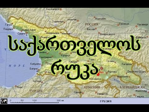
MAP OF GEORGIA [ with facts ] [ საქართველოს რუკა ]
Georgia is a country located in the Caucasus, at the intersection of Eastern Europe and Western Asia. It is bounded by the Black Sea to the west, by Russia to the north and east, by Turkey to the southwest, by Armenia to the south, and by Azerbaijan to the southeast. The country covers an area of 69,700 square kilometres (26,900 sq mi), and has a population of 3.7 million people (excluding the Russian-occupied Georgian territories). Georgia is a representative democracy governed as a unitary parliamentary republic. Tbilisi is its capital as well as its largest city, and is home to roughly a third of the Georgian population.
During the classical era, several independent kingdoms became established in what is now Georgia, such as Colchis and Iberia. In the early 4th century, ethnic Georgians officially adopted Christianity, which contributed to the spiritual and political unification of the early Georgian states. In the Middle Ages, the unified Kingdom of Georgia emerged and reached its Golden Age during the reign of King David IV and Queen Tamar in the 12th and early 13th centuries. Thereafter, the kingdom declined and eventually disintegrated under the hegemony of various regional powers, including the Mongols, the Ottoman Empire, and the successive dynasties of Persia. In 1783, one of the Georgian kingdoms entered into an alliance with the Russian Empire, which proceeded to annex the territory of modern Georgia in a piecemeal fashion throughout the 19th century.
After the Russian Revolution in 1917, Georgia emerged as an independent republic under German protection. Following World War I, Georgia was invaded and annexed by the Soviet Union in 1922, becoming one of its fifteen constituent republics. By the 1980s, an independence movement emerged and grew quickly, leading to Georgia's secession from the Soviet Union in April 1991. For most of the subsequent decade, post-Soviet Georgia suffered from economic crisis, political instability, ethnic conflict, and secessionist wars in Abkhazia and South Ossetia. Following the bloodless Rose Revolution in 2003, Georgia strongly pursued a pro-Western foreign policy; it introduced a series of democratic and economic reforms aimed at integration into the European Union and NATO. The country's Western orientation soon led to worsening relations with Russia, which culminated in the Russo-Georgian War of 2008; Russia has since been occupying a portion of Georgia. Georgia is a mountainous country situated almost entirely in the South Caucasus, while some slivers of the country are situated north of the Caucasus Watershed in the North Caucasus. The country lies between latitudes 41° and 44° N, and longitudes 40° and 47° E, with an area of 67,900 km2 (26,216 sq mi). The Likhi Range divides the country into eastern and western halves. Historically, the western portion of Georgia was known as Colchis while the eastern plateau was called Iberia.
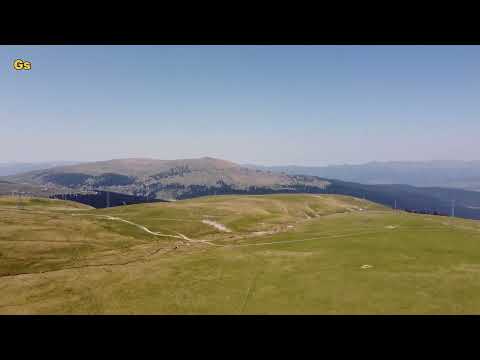
The Greater Caucasus Mountain Range forms the northern border of Georgia.[220] The main roads through the mountain range into Russian territory lead through the Roki Tunnel between Shida Kartli and North Ossetia and the Darial Gorge (in the Georgian region of Khevi). The southern portion of the country is bounded by the Lesser Caucasus Mountains.[220] The Greater Caucasus Mountain Range is much higher in elevation than the Lesser Caucasus Mountains, with the highest peaks rising more than 5,000 metres (16,404 ft) above sea level.
The highest mountain in Georgia is Mount Shkhara at 5,068 metres (16,627 ft), and the second highest is Mount Janga (Dzhangi–Tau) at 5,059 m (16,598 ft) above sea level. Other prominent peaks include Mount Kazbek at 5,047 m (16,558 ft), Shota Rustaveli 4,860 m (15,945 ft), Tetnuldi 4,858 m (15,938 ft), Ushba 4,700 m (15,420 ft), and Ailama 4,547 m (14,918 ft). Out of the abovementioned peaks, only Kazbek is of volcanic origin. The region between Kazbek and Shkhara (a distance of about 200 km (124 mi) along the Main Caucasus Range) is dominated by numerous glaciers.
Mount Kazbek in eastern Georgia
The term Lesser Caucasus Mountains is often used to describe the mountainous (highland) areas of southern Georgia that are connected to the Greater Caucasus Mountain Range by the Likhi Range. The area can be split into two separate sub-regions; the Lesser Caucasus Mountains, which run parallel to the Greater Caucasus Range, and the Southern Georgia Volcanic Highland.[citation needed] The overall region can be characterized as being made up of various, interconnected mountain ranges (largely of volcanic origin) and plateaus that do not exceed 3,400 metres (11,155 ft) in elevation. Prominent features of the area include the Javakheti Volcanic Plateau, lakes, including Tabatskuri and Paravani, as well as mineral water and hot springs. Two major rivers in Georgia are the Rioni and the Mtkvari #georgia #mapstudy • MAP OF ASIA


მსგავსი ვიდეოები

Learn Country Names in Georgian #learngeorgianlanguage #ქართ...
Georgian2go

GEORGIA - TAMAR THE GREAT თამარ მეფე ALL VOICED QUOTES \u002...
ikiga Gaming Official

Surami Fortress / სურამის ციხე / Крепость Сурами / - Georgia...
Aerial Explorer

Travel Tbilisi and Kekcheti regions - visiting Georgia | T...
WineMap TV - EN
travel in Georgia|მოგზაურობა საქართველოში|путешествие в груз...
gia surmanidze [gs]

A Week in Kazbegi, Georgia (Gergeti Glacier, Juta, Truso and...
Going The Whole Hogg | Kim \u0026 Del

Martkopi monastery, Deity church / მარტყოფის ღვთაების მონასტ...
Aerial Explorer
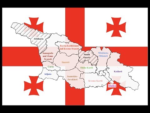
Explained: Georgia's Regions
Visiting-Georgia